
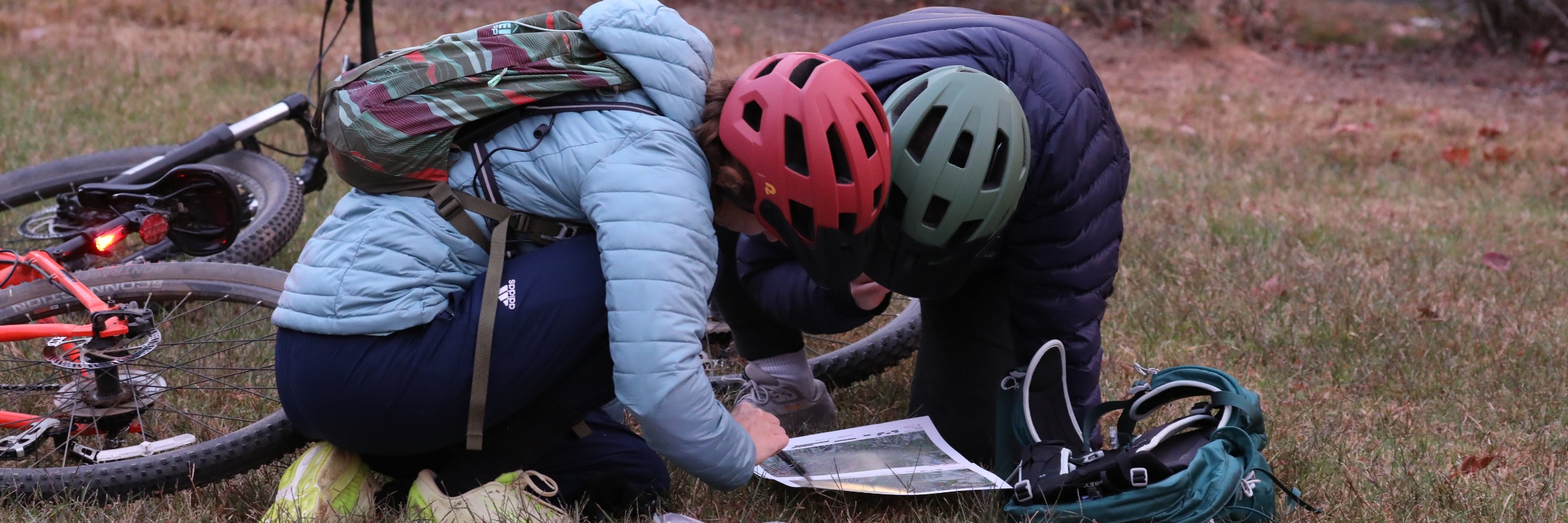

Neck of the Woods Adventure Race
About this race
Whether you've never heard of adventure racing or are a seasoned pro looking for a partial-day challenge, this event is for you.
WHAT: 3rd Annual “Neck of the Woods” Adventure Race (5-hour). Solo or teams of up to 4 persons (1,2,3 or 4 on a team)
WHEN: October 24th, 2026 0700 mandatory pre-race briefing, 0730 launch time, must finish by 1230
WHERE: 760 Craft Works, Huntersville, NC
COST: $40 Per Person (All proceeds benefit the Firefighters Burned Children's Fund)
NEW FOR 2026: Larger, more-readable maps. Some optional checkpoints will be on mountain bike trails. There will be a remote transition area to drop off your bikes, helmets and bike lights before race check-in. Back this year, learn some things about the Huntersville area checkpoints and prove it on your score card.
This adventure race will be like a scavenger hunt on bike and on foot (no paddle/swim/water section). That doesn't necessarily mean you won't get wet.
All maps are pre-plotted with possible checkpoints to find. Each checkpoint you find earns you points. The team/solo with the most points in the least amount of time wins (Solo & Team category awards). All mandatory checkpoints and most of the other checkpoints are easily found near paths/creeks/intersections/features. A few optional checkpoints may be a little trickier to find. Team members stay together and work together the entire race. You can choose to go all out and attempt every checkpoint OR you can just get the mandatory checkpoints OR any number of checkpoints between. There is a 5-hour time limit. There is no set route. There is no sequence to the checkpoints. You decide your route and manage your own time. This can be by yourself, with your family, your friends, your coworkers, etc (teams of 1-4).
Mandatory Supplies for each participant: Bike, Bike Helmet (while riding), Blinking Rear Bike Light (while riding), Reflective Vest (while on foot), Food/Nutrition, Water
Mandatory Team Supplies carried at all times: Compass, Phone (waterproof container)
Distances are approximate and depend on your race strategy. However, teams that make it to every checkpoint and bonus point with no navigation errors should plan on about 25 miles of biking and 5-6 miles of trekking. The minimum distance if you only get the mandatory checkpoints is about 14-15 miles of biking and 3-4 miles of trekking. The miles are not continuous as the race has separate sections and you are constantly navigating and renegotiating routes.
You will be responsible for your own nutrition and hydration throughout the race. There will be a transition area with water and Gatorade at a mid-point(ish) transition area, but will obviously not be accessible while you are out hunting for checkpoints.
The bike sections are mostly paved roads and greenways with some optional checkpoints on mountain bike trails. A mountain bike would work best. However, if you only have (or need to borrow from a friend) a road bike or even a beach cruiser, you can ride to all the mandatory bike points. The optional bike points will need some strategic creativity if you don't have a bike that can ride off road. Helmets and blinking bike lights are required at all times while on the bikes.
There are always race day surprises as part of the fun, but here are a couple hints to the day. There will be more than one map. You will have to earn each of your maps at different times throughout the race. Some of the farther checkpoints marked as “bonus” will have descriptions of possible bonus points you can find close by. There will also be a non-mandatory orienteering section worth lots of points...practice basic compass skills and estimating distance to stay competitive. Here is a video to show you how easy it will be:
Compass Heading
TRAINING TIPS: Get some miles on the bike you will be using for the race. Get some foot miles on pavement, trails and/or gravel paths. On your training rides and runs, carry the pack you will use for water and nutrition at the event. Practice transitioning from miles on a bike to miles on foot and vice versa. Know how to read a compass (basic North, East, South & West for most points AND headings/distances for maximum points).
REGISTRATION ENDS 10/20. REGISTER BY 10/8 TO GUARANTEE A T-SHIRT
Pick your distance
Adventure race
Adventure Race
Typical race-day weather
Based on 2 years of Open-Meteo archive data for this event's race dates in Huntersville, plus the 3 days either side.
The sun rises at 7:37 AM and sets at 6:37 PM local time (EDT) in Huntersville on October 24, 2026 — 10h 59m of daylight.
Course
No course map published yet.
The organizer hasn't released a route for this event, and we don't publish guesses. If you're the organizer, send us a GPX file and we'll draw the profile.
Reviews
Done this event?
If you've participated in this event, share your experience with other runners
Other races near Huntersville
Different organizers, within 40 miles, in the next three months

NorthStone Turkey Trot
Atd 5K for Heroes

Cfnc Steps for Hope
20th Annual Lake Norman Half Marathon Turkey Trot 10K & 5K
Where this page comes from. Race details were last updated on . We re-check listings regularly and again in the week before race day.
- Entries, prices, waves and inclusions — the event's official registration page
- Temperature and humidity — Copernicus ERA5 reanalysis via Open-Meteo (CC BY 4.0)
- Elevation and terrain relief — Copernicus DEM GLO-90, ESA (CC BY 4.0)
- Comparisons and counts — Race Discovery calendar, 10 Huntersville events
Spotted something wrong? Tell us and we'll fix it.