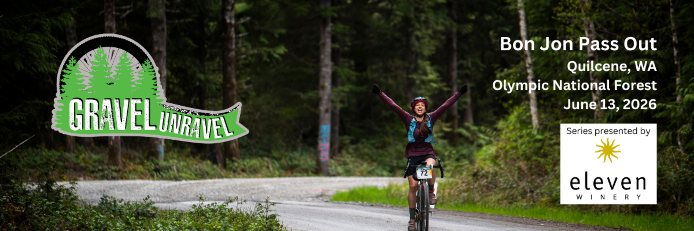
Gravel Unravel - Bon Jon Pass Out
About this race
The Gravel Unravel Experience
Gravel Unravel is an endurance gravel bicycling series on the Olympic Peninsula of Washington State. This series is brought to you by a partnership between Peninsula Adventure Sports and La Vogue Cyclery This event is designed for those who wish to challenge their physical abilities to the maximum while enjoying the lushness of Olympic National Forest. Participants can ride short (23-32 miles), medium (46-55 miles), or long (69-80 miles) distances on majority gravel courses (percent varies by race/distance) while enjoying towering evergreens and vivid green moss and ferns. There are both competitive and non-competitive Gran Fondo style divisions, and all are welcome to give the Gravel Unravel a try on their own terms.
We are grateful to our Series Sponsor Eleven Winery for making Gravel Unravel happen again for 2026! Eleven Winery has been with us since year one of Gravel Unravel, and we thank they for their unwavering support.
- Race 1: Bon Jon Pass Out - June 13, 2026 (Peninsula Adventure Sports) - SPOTS LIMITED TO 400 RIDERS
- Race 2: Why-Not-Chee - July 18, 2026 (La Vogue Cyclery) - SPOTS LIMITED TO 400 RIDERS
Racing categories are Open, Open Masters (45+), Open Super Masters (60+), Non-Binary, Womens Open, Womens Masters (45+), Womens Super Masters (60+), Juniors (under 18), and Singlespeed. The top three overall winners (Men, Women, and More) in each distance will receive an award / podium.
You can also Gravel Unravel in the non-competitive Gran Fondo style for the Short and Medium Courses. Loosely translated from Italian as “the big challenge”, think of it as more of a group ride or tour. Set your own goal, be it to go fast or ride for fun, or heck just to finish! E-bikes are allowed in the non-competitive ride as a separate category.
Bon Jon Pass Out
The village of Quilcene is perfectly placed at the base of the Olympic Mountains, and along Quilcene Bay. This town is synonymous with hospitality, and especially welcoming are the great folks at Worthington Park, where we will be based for the day. A portion of race proceeds will support the Quilcene Museum/Worthington Park and also to Count me in for Quilcene, both local non-profit organizations.
After leaving Worthington Park, riders head for their first challenge – Bon Jon Pass. Luckily June is when the wild rhododendrons are in full bloom. Spotlighted against the deep green background of the forest, the blooms are sure to brighten up what might seem like an endless ascent. After Bon Jon Pass, enjoy the views and ridges, returning via Lords Lake Loop. Well, except the long course riders – they get to climb Bon Jon again!
Pricing for Bon Jon Pass Out:
-
Adult pricing is $75 per person, regardless of distance.
-
Junior (under 18) = $35 (any distance)
-
Price increase of $10 one week ahead of the race
-
Race Bundle Get $5 off each race if you register for Bon Jon Pass Out and Why-Not-Chee at the same time.
Price increase of $10 one week ahead of the race
SPOTS LIMITED TO 400 RIDERS.
What’s included in your Bon Jon Pass Out entry fee?
In addition to an epic outdoor experience in the far northwest corner, all participants receive a professional, well-organized event, RFID timing, a well-marked course, on-course snacks and medical support, mechanical support, a finisher token of badassness, and post-race hot food and cold drinks. There will be a beer garden at the race finish should you want to purchase a frosty bevvie, and we will have Gravel Unravel t-shirts available for purchase as part of registration.
Camping Options:
- New for 2026, Worthington Park is doing a trial to allow 10 vehicles to camp at the park, in the main parking area. This will be van or car camping only (no large RVs, trailers, or tents). Cost is $20 which is a donation to the Historical Museum and used for the upkeep of the park. There will be Sanicans and drinking water on site. No campfires. You can reserve a spot as part of the race registration process. If you have already registered and want a one of the spots, go into your registration and click on "Add-on Management" and add it on. If all goes well, we hope they will increase the allowed number for next year.
- If you prefer to be in a more secluded area, or have a large RV, trailer, or tent, we have once again arranged camping for riders 10 miles away at Twana Springs (Lake Leland) with Sheryl - click HERE to book a spot. We highly recommend camping at this beautiful property!
- In Quilcene there is a county campground just behind the Community Center. 9 sites, first come first serve.
- Dosewallips State Park 12 miles away - make reservations.
Lodging
Please see: North Hood Canal Chamber of Commerce or Olympic Peninsula Visitor Bureau.
Refund Policy
- No refunds, however you will have the choice during the registration process to buy cancellation insurance (coverage not available for Canadian riders). With the insurance, you can get a full refund if you are unable to attend the event due to several covered reasons including accident, illness and family emergency. Full insurance information HERE.
- Transfers are allowed until 3 days before the race. Follow these instructions to transfer to another participant.
- No deferrals to next year
- If we are forced to cancel for any reason, runners will get a free transfer to the next year, or an 80% refund.
Any other information, including course maps, can be found on our website.
The Gravel Unravel - Bon Jon Pass Out brings an exciting Ultra to Quilcene, Washington on June 13, 2026. Don't miss this beautiful event!
Pick your distance
Gravel biking
Short Course - Open
This course has approximately 4,000 feet cumulative elevation gain and is 50% gravel, with the rest paved or “rustic” paved. Course map, elevation profile, description, GPS download: https://ridewithgps.com/routes/31776039 There will be hydration/snack stations and portable toilets at approximate miles 11 and 22.
Medium Course - Open
This course has approximately 6,000 feet cumulative elevation gain and is 60% gravel, with the rest pave or “rustic” paved. Course map, elevation profile, description, GPS download: https://ridewithgps.com/routes/31776043 There will be hydration/snack stations and portable toilets at approximate miles 11, 22, 33, and 45.
Long Course - Open
This course is approximately 9,000 feet cumulative elevation gain is 70% gravel, with the rest paved or “rustic” paved. Course map, elevation profile, description, GPS download: https://ridewithgps.com/routes/31776041 There will be hydration/snack stations and portable toilet at approximate miles 11, 22, 33, 45, 55, and 70.
Short Course - Open Masters (45+)
This course has approximately 4,000 feet cumulative elevation gain and is 50% gravel, with the rest paved or “rustic” paved. Course map, elevation profile, description, GPS download: https://ridewithgps.com/routes/31776039 There will be hydration/snack stations and portable toilets at approximate miles 11 and 22.
Short Course - Womens
This course has approximately 4,000 feet cumulative elevation gain and is 50% gravel, with the rest paved or “rustic” paved. Course map, elevation profile, description, GPS download: https://ridewithgps.com/routes/31776039 There will be hydration/snack stations and portable toilets at approximate miles 11 and 22.
Short Course - Womens Masters (45+)
This course has approximately 4,000 feet cumulative elevation gain and is 50% gravel, with the rest paved or “rustic” paved. Course map, elevation profile, description, GPS download: https://ridewithgps.com/routes/31776039 There will be hydration/snack stations and portable toilets at approximate miles 11 and 22.
Short Course - Non Binary
This course has approximately 4,000 feet cumulative elevation gain and is 50% gravel, with the rest paved or “rustic” paved. Course map, elevation profile, description, GPS download: https://ridewithgps.com/routes/31776039 There will be hydration/snack stations and portable toilets at approximate miles 11 and 22.
Short Course - Single Speed
This course has approximately 4,000 feet cumulative elevation gain and is 50% gravel, with the rest paved or “rustic” paved. Course map, elevation profile, description, GPS download: https://ridewithgps.com/routes/31776039 There will be hydration/snack stations and portable toilets at approximate miles 11 and 22.
Short Course - Juniors (under 18)
This course has approximately 4,000 feet cumulative elevation gain and is 50% gravel, with the rest paved or “rustic” paved. Course map, elevation profile, description, GPS download: https://ridewithgps.com/routes/31776039 There will be hydration/snack stations and portable toilets at approximate miles 11 and 22.
Short Course - Non Competitive Gran Fondo
This course has approximately 4,000 feet cumulative elevation gain and is 50% gravel, with the rest paved or “rustic” paved. Course map, elevation profile, description, GPS download: https://ridewithgps.com/routes/31776039 There will be hydration/snack stations and portable toilets at approximate miles 11 and 22.
Short Course - Non Competitive Gran Fondo E-Bike
This course has approximately 4,000 feet cumulative elevation gain and is 50% gravel, with the rest paved or “rustic” paved. Course map, elevation profile, description, GPS download: https://ridewithgps.com/routes/31776039 There will be hydration/snack stations and portable toilets at approximate miles 11 and 22.
Medium Course - Open Masters (45+)
This course has approximately 6,000 feet cumulative elevation gain and is 60% gravel, with the rest pave or “rustic” paved. Course map, elevation profile, description, GPS download: https://ridewithgps.com/routes/31776043 There will be hydration/snack stations and portable toilets at approximate miles 11, 22, 33, and 45.
Medium Course - Womens
This course has approximately 6,000 feet cumulative elevation gain and is 60% gravel, with the rest pave or “rustic” paved. Course map, elevation profile, description, GPS download: https://ridewithgps.com/routes/31776043 There will be hydration/snack stations and portable toilets at approximate miles 11, 22, 33, and 45.
Medium Course - Womens Masters (45+)
This course has approximately 6,000 feet cumulative elevation gain and is 60% gravel, with the rest pave or “rustic” paved. Course map, elevation profile, description, GPS download: https://ridewithgps.com/routes/31776043 There will be hydration/snack stations and portable toilets at approximate miles 11, 22, 33, and 45.
Medium Course - Non Binary
This course has approximately 6,000 feet cumulative elevation gain and is 60% gravel, with the rest pave or “rustic” paved. Course map, elevation profile, description, GPS download: https://ridewithgps.com/routes/31776043 There will be hydration/snack stations and portable toilets at approximate miles 11, 22, 33, and 45.
Medium Course - Single Speed
This course has approximately 6,000 feet cumulative elevation gain and is 60% gravel, with the rest pave or “rustic” paved. Course map, elevation profile, description, GPS download: https://ridewithgps.com/routes/31776043 There will be hydration/snack stations and portable toilets at approximate miles 11, 22, 33, and 45.
Medium Course - Juniors (under 18)
This course has approximately 6,000 feet cumulative elevation gain and is 60% gravel, with the rest pave or “rustic” paved. Course map, elevation profile, description, GPS download: https://ridewithgps.com/routes/31776043 There will be hydration/snack stations and portable toilets at approximate miles 11, 22, 33, and 45.
Medium Course - Non Competitive Gran Fondo
This course has approximately 6,000 feet cumulative elevation gain and is 60% gravel, with the rest pave or “rustic” paved. Course map, elevation profile, description, GPS download: https://ridewithgps.com/routes/31776043 There will be hydration/snack stations and portable toilets at approximate miles 11, 22, 33, and 45.
Medium Course - Non Competitive Gran Fondo E-Bike
This course has approximately 6,000 feet cumulative elevation gain and is 60% gravel, with the rest pave or “rustic” paved. Course map, elevation profile, description, GPS download: https://ridewithgps.com/routes/31776043 There will be hydration/snack stations and portable toilets at approximate miles 11, 22, 33, and 45.
Long Course - Open Masters (45+)
This course is approximately 9,000 feet cumulative elevation gain is 70% gravel, with the rest paved or “rustic” paved. Course map, elevation profile, description, GPS download: https://ridewithgps.com/routes/31776041 There will be hydration/snack stations and portable toilet at approximate miles 11, 22, 33, 45, 55, and 70.
Long Course - Womens
This course is approximately 9,000 feet cumulative elevation gain is 70% gravel, with the rest paved or “rustic” paved. Course map, elevation profile, description, GPS download: https://ridewithgps.com/routes/31776041 There will be hydration/snack stations and portable toilet at approximate miles 11, 22, 33, 45, 55, and 70.
Long Course - Womens Masters (45+)
This course is approximately 9,000 feet cumulative elevation gain is 70% gravel, with the rest paved or “rustic” paved. Course map, elevation profile, description, GPS download: https://ridewithgps.com/routes/31776041 There will be hydration/snack stations and portable toilet at approximate miles 11, 22, 33, 45, 55, and 70.
Long Course - Non Binary
This course is approximately 9,000 feet cumulative elevation gain is 70% gravel, with the rest paved or “rustic” paved. Course map, elevation profile, description, GPS download: https://ridewithgps.com/routes/31776041 There will be hydration/snack stations and portable toilet at approximate miles 11, 22, 33, 45, 55, and 70.
Long Course - Single Speed
This course is approximately 9,000 feet cumulative elevation gain is 70% gravel, with the rest paved or “rustic” paved. Course map, elevation profile, description, GPS download: https://ridewithgps.com/routes/31776041 There will be hydration/snack stations and portable toilet at approximate miles 11, 22, 33, 45, 55, and 70.
Long Course - Juniors (under 18)
This course is approximately 9,000 feet cumulative elevation gain is 70% gravel, with the rest paved or “rustic” paved. Course map, elevation profile, description, GPS download: https://ridewithgps.com/routes/31776041 There will be hydration/snack stations and portable toilet at approximate miles 11, 22, 33, 45, 55, and 70.
Short Course - Open Super Masters (60+)
This course has approximately 4,000 feet cumulative elevation gain and is 50% gravel, with the rest paved or “rustic” paved. Course map, elevation profile, description, GPS download: https://ridewithgps.com/routes/31776039 There will be hydration/snack stations and portable toilets at approximate miles 11 and 22.
Short Course - Womens Super Masters (60+
This course has approximately 4,000 feet cumulative elevation gain and is 50% gravel, with the rest paved or “rustic” paved. Course map, elevation profile, description, GPS download: https://ridewithgps.com/routes/31776039 There will be hydration/snack stations and portable toilets at approximate miles 11 and 22.
Medium Course - Open Super Masters (60+)
This course has approximately 6,000 feet cumulative elevation gain and is 60% gravel, with the rest pave or “rustic” paved. Course map, elevation profile, description, GPS download: https://ridewithgps.com/routes/31776043 There will be hydration/snack stations and portable toilets at approximate miles 11, 22, 33, and 45.
Medium Course - Womens Super Masters (60+)
This course has approximately 6,000 feet cumulative elevation gain and is 60% gravel, with the rest pave or “rustic” paved. Course map, elevation profile, description, GPS download: https://ridewithgps.com/routes/31776043 There will be hydration/snack stations and portable toilets at approximate miles 11, 22, 33, and 45.
Long Course - Open Super Masters (60+)
This course is approximately 9,000 feet cumulative elevation gain is 70% gravel, with the rest paved or “rustic” paved. Course map, elevation profile, description, GPS download: https://ridewithgps.com/routes/31776041 There will be hydration/snack stations and portable toilet at approximate miles 11, 22, 33, 45, 55, and 70.
Long Course - Womens Super Masters (60+)
This course is approximately 9,000 feet cumulative elevation gain is 70% gravel, with the rest paved or “rustic” paved. Course map, elevation profile, description, GPS download: https://ridewithgps.com/routes/31776041 There will be hydration/snack stations and portable toilet at approximate miles 11, 22, 33, 45, 55, and 70.
Weather Overview
These values represent the 4-year monthly averages for June in Quilcene.
About Quilcene
Gravel Unravel - Bon Jon Pass Out takes place in Quilcene, Washington, United States. The local timezone is America/Los_Angeles.
Reviews
Done this event?
If you've participated in this event, share your experience with other runners
Race information has been sourced from the event's official website and other publicly available resources. For the most up-to-date details, please refer to the official website directly. If you notice any incorrect or missing information, don't hesitate to reach out to us by email.